❤️ Heart Lake
California
🚗 Check available routes: 🌋 Crater Lake → San Francisco Scenic Road Trip
📍 Location: Near Mount Shasta, Shasta–Trinity National Forest
🥾 Trailhead: Castle Lake Day Use Area
🗓️ Best time to hike: June through October
⏳ Recommended time: 1.5–3 hours
🌐 Official website: U.S. Forest Service — Heart Lake
📊 Trail Metrics
| Metric | Details |
|---|---|
| 🥾 Distance | Approximately 2.2 miles round trip |
| 📈 Elevation gain | Approximately 600 feet |
| ⛰️ Highest elevation | Approximately 6,050 feet |
| ⏱️ Typical hiking time | 1.5–3 hours |
| 🔁 Route type | Out and back |
| 🟠 Difficulty | Moderate |
| 🐕 Dogs | Generally allowed; keep under control and follow posted rules |
| 🎟️ Permit | No standard day-hiking permit normally required |
| 🚻 Restrooms | Limited or unavailable at the trailhead |
Route measurements vary between hiking apps. Some GPS tracks report closer to 2.5–3 miles and 700–850 feet of gain, especially when hikers explore beyond Heart Lake or continue toward the ridge above it.
See the community route on AllTrails — Heart Lake Trail from Castle Lake and the local route summary from the Mount Shasta Trail Association.
🏞️ About the Hike
Heart Lake is a small alpine lake located above Castle Lake in the mountains west of Mount Shasta.
The hike begins at the Castle Lake parking area and climbs steadily through forest, rocky terrain, and open slopes. As the trail gains elevation, it provides increasingly wide views over Castle Lake.
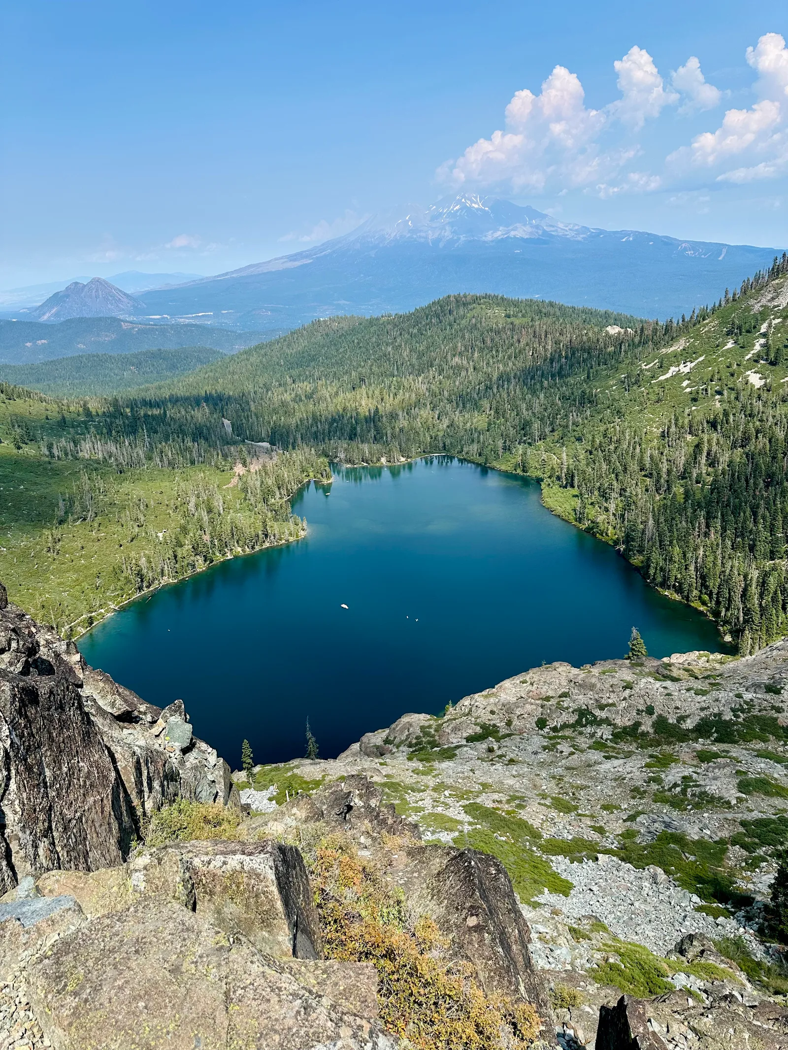
Heart Lake itself is small, but the surrounding ridge offers one of the best viewpoints of Mount Shasta, Black Butte, Castle Lake, and the surrounding Trinity Divide.
The U.S. Forest Service Heart Lake page describes the traditional route as beginning at the east end of the Castle Lake parking area.
✨ Why Hike It
The Heart Lake Trail is especially known for:
- 🏔️ Expansive views of Mount Shasta
- 💙 An alpine lake above Castle Lake
- 📸 Excellent sunrise and sunset photography
- 🌲 Forest and rocky alpine terrain
- 🌼 Seasonal wildflowers
- ❄️ Snowshoeing opportunities in winter
- 🥾 A high scenic payoff for a relatively short hike
📅 Best Time to Hike
☀️ June–October — Best Overall
Summer through early fall usually provides the easiest trail conditions.
- June: Lingering snow and early wildflowers are possible
- July: Warmer weather and generally better trail access
- August: Dry conditions, but wildfire smoke is possible
- September: Cooler temperatures and fewer visitors
- October: Fall conditions, with possible early snow or ice
The Mount Shasta Trail Association lists approximately May through November as the typical hiking season, depending on snow conditions.
❄️ November–May — Snow Travel
The route is also used for snowshoeing and winter hiking, but snow can cover the trail and make navigation difficult.
Winter visitors should expect:
- Deep or uneven snow
- Icy slopes
- Hidden trail markers
- Rapidly changing weather
- Limited parking
- Possible avalanche terrain near steeper slopes
Check Shasta–Trinity National Forest conditions and the Mount Shasta Avalanche Center before winter travel.
🚗 Getting There
The trail begins at the Castle Lake Day Use Area, approximately 10 miles southwest of Mount Shasta City.
The usual approach is:
- Take Interstate 5 to Mount Shasta
- Follow local roads toward Lake Siskiyou
- Continue on Castle Lake Road
- Park near the east end of Castle Lake
The official Castle Lake page provides current recreation and access information.
Castle Lake Road is paved, but winter snow and ice may make the upper section difficult or temporarily inaccessible.
🧭 Trail Navigation
The trail begins near the east end of the Castle Lake parking area and climbs above the eastern side of Castle Lake.
The route has historically included several informal paths. Follow the most established trail and avoid cutting across meadows or creating new routes.
Important navigation notes:
- The route may be faint in rocky areas
- Snow can completely cover the trail
- Download an offline map before arriving
- Do not depend on cell service
- Heart Lake may be easy to miss because it is small
- Continuing above the lake adds distance, elevation gain, and exposure
The Forest Service’s Alpine Lakes of the Trinity Divide guide includes Heart Lake and nearby trail information.
🥾 Difficulty
The hike is short but climbs steadily.
The primary challenges are:
- Approximately 600 feet of gain over a short distance
- Rocky and uneven trail surfaces
- Loose gravel
- Exposed sunny sections
- Route-finding in snow or low visibility
Most hikers with moderate fitness can complete the standard route, but it may feel strenuous for beginners or visitors arriving directly from low elevation.
⚠️ Safety
Visitors should prepare for mountain conditions.
Bring:
- Water
- Sun protection
- Supportive hiking shoes
- Warm layers
- Offline navigation
- Basic first-aid supplies
Potential hazards include:
- Snow and ice
- Loose rock
- Slippery slopes
- Wildfire smoke
- Thunderstorms
- Sudden temperature changes
- Limited cell service
Avoid exposed ridges during thunderstorms.
🔥 Wildfire and Smoke
Wildfire smoke can reduce visibility and air quality during summer and fall.
Before hiking, review:
- Forest conditions
- Forest alerts and closures
- Local air-quality forecasts
- Fire restrictions
Do not enter closed areas.
🐻 Wildlife and Leave No Trace
Black bears and other wildlife live in the area.
Visitors should:
- Pack out all trash
- Never feed wildlife
- Keep food secured
- Stay on established trails
- Avoid damaging wildflowers
- Do not build new fire rings
- Leave the lakeshore and viewpoints as found
Heart Lake is small and sensitive to heavy visitor use.
🐕 Dogs
Dogs are generally allowed in the national forest unless otherwise posted.
Keep dogs:
- Under control
- Away from wildlife
- Out of sensitive vegetation
- Supplied with enough water
- Leashed where required
Snow, hot rocks, and sharp terrain can be difficult for pets.
✅ Before You Go
Check the relevant source shortly before hiking: